Antic Software
Maps and Legends can be used for just plain fun or
as a serious educational or business tool, enabling you to produce
small scale maps of any area of the Earth. Before we begin, however,
I must clear up a popular misconception concerning the Legends part
of the title for those who might be disappointed to find that the
program does not contain any heroic stories of myth and past
adventure. The word legend in this context applies to detail on a
map such as you would find representing roads and rivers etc. In
speaking to several people I was surprised to find that this was not
generally known. Obviously one of those things, learned from Boy
Scout days that you assume everybody knows until you ask!
As far as the program goes, the Legends part
appears to consist only of the State boundaries of the U.S.A. which
is something of a disappointment but is understandable when you
consider the enormous amount of other detail that has had to be
packed into the program to enable close-up views of any land area on
Earth. To compensate, detail can be added to any map created by the
program by using various freehand drawing tools and custom maps can
be created for various uses. In addition maps can be saved to disk
in DEGAS format and enhanced with that or other graphics programs.
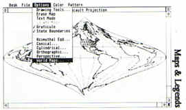
The built in features enable many different world maps to be created
using a number of different projections. It is a sure bet that you
are unlikely to be aware of the many different ways of mapping the
world and this program will enlighten you considerably. A map can be
drawn viewed from any imaginary point above the Earth so that it can
be centred on your home town or at any point on land or sea. Once
the chosen centre in latitude and longitude is established the map
can be drawn from any point above the surface from tens to tens of
thousand miles or kilometres. Viewed from a distance of 10,000 miles
the whole of the Earth's surface is seen whilst from the same
co-ordinates you can zoom in to view just a portion of coastline.
Sadly, as you get closer the amount of detail becomes less and small
islands such as the Canary Islands are hardly recognisable but when
considering the amount of information required for such plotting it
is hardly surprising. All detail is held in memory and the only way
to achieve finer resolution would be to load different areas in from
disk. Maybe a later more sophisticated version will have this
facility. One other criticism that I have is that there is no
facility to print out finished maps other than with the built in
Alternate-Help screen dump. The only way to achieve a 'clean' print
out is to load the picture into another program such as DEGAS.
Don't let these minor criticisms detract, however,
from the overall use or enjoyment of Maps and Legends. As an
entertainment it will give you hours and hours of enjoyment
exploring different aspects of the world but it can also be used as
a tool in presentations, projects and school work. Above all it
allows you to be creative and, by using its built in co-ordinates,
you can design maps of beauty and variety. Maps and Legends runs in
both monochrome and colour.
top